How Ditio and Infrakit Connect Field Data with the Project Model
Construction projects generate vast amounts of site data every single day. Yet many contractors find that important information ends up scattered across different systems, spreadsheets and reports. When production data is not turned into action while the project is still under way, the result can be delays, loss of progress control and weaker cost management.
This is where the combination of Ditio and Infrakit comes in.
Through digital data capture from the construction site, Ditio gives contractors control over hours, crew, mass transport, documentation and production in real time. When this data is connected with Infrakit’s map-based project platform, the project manager gets a direct link between what is happening on site and the planned model.
”Ditio tells you what is happening in the field. Infrakit shows where it is happening. Together we give contractors the ability to follow the project’s progress against plan, in real time.”
— Steffen Nerdal, CCO at Ditio AS
Visa Hokkanen, Chief Product Officer at Infrakit, believes the combination of Infrakit and Ditio gives contractors a unique advantage:

“We help contractors and infrastructure owners build more precisely, more efficiently and with better control over both time and costs. When data from Ditio is connected with Infrakit, users get a complete picture of the project in real time.”
— Visa Hokkanen, Chief Product Officer at Infrakit
How Ditio and Infrakit complement each other
The two platforms solve different challenges, but reinforce each other.
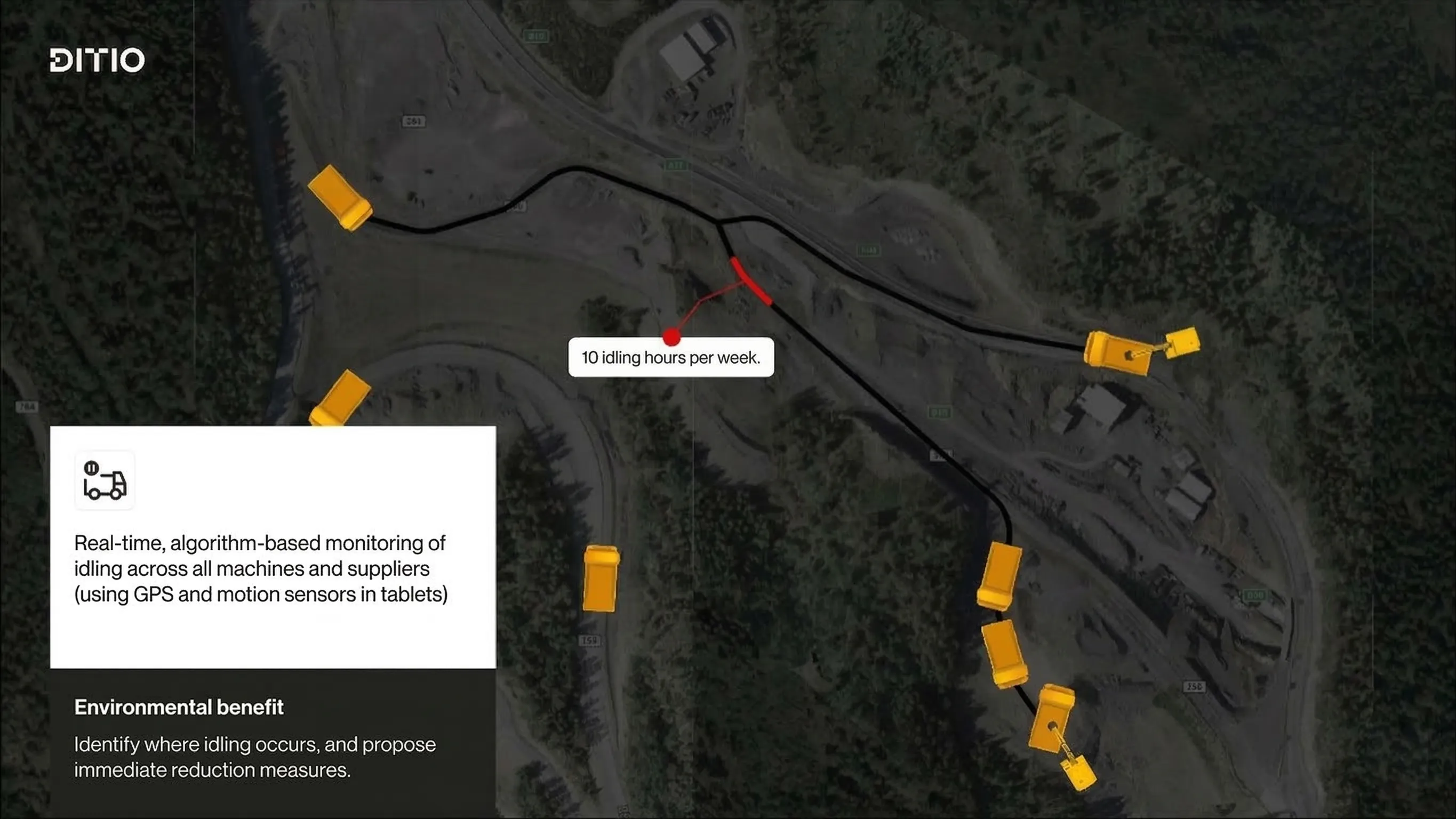
Ditio collects and structures data from daily operations. Hours, crew, deviations, checklists, production and mass transport are documented continuously and made available to the entire project organisation.
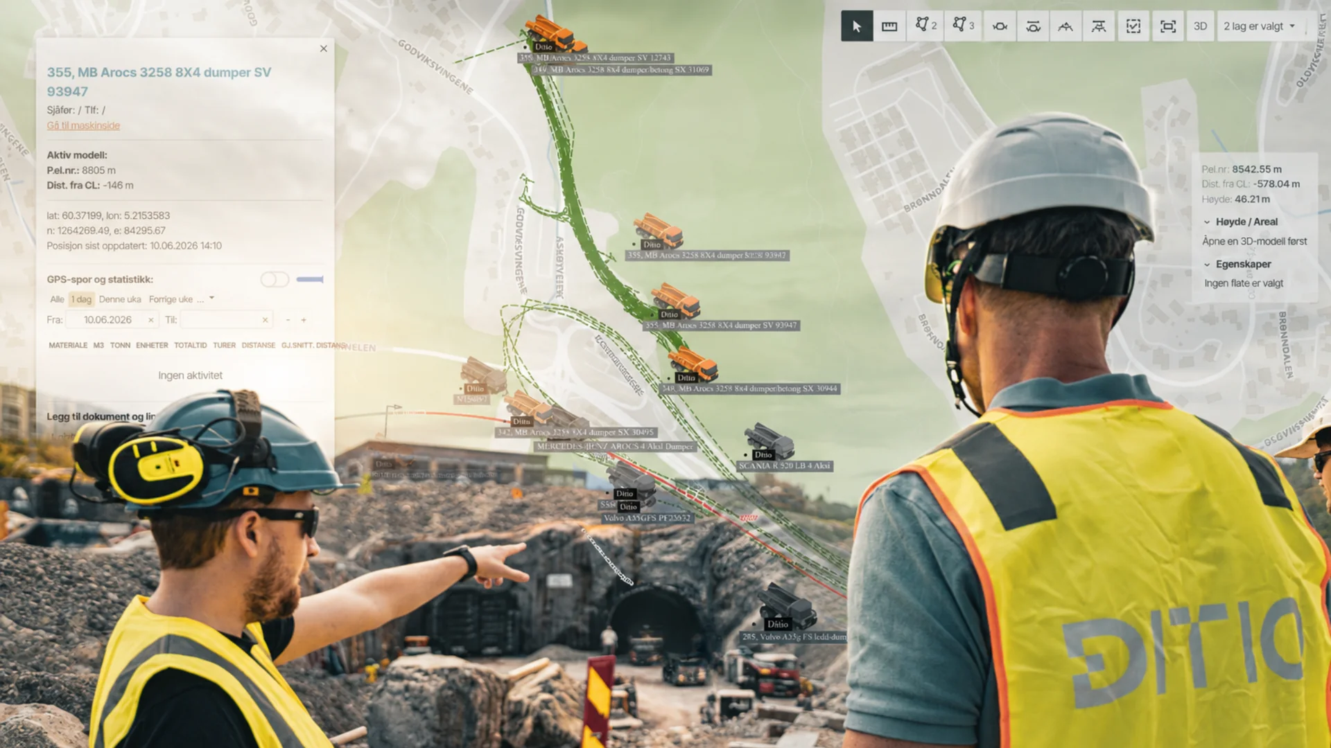
Infrakit brings together map data, BIM models, machine control, surveying and drone data in one solution. The project is visualised here so that everyone involved works from the same up-to-date situational picture.
When field data and model information are connected, the project team gains a new kind of project understanding. This provides the foundation for better digital project management and more effective collaboration between project management, setting-out personnel, machine operators and field staff.
Together the solutions provide a holistic project understanding. Project management gains insight into both production in the field and how the work is developing relative to the model and the plan. This makes it easier to detect deviations early, coordinate work more effectively and make faster decisions based on up-to-date information.
Read also
Why documentation of mass transport is becoming more important in construction projects
Traceability requirements are increasing. Learn how digital solutions provide better project control and financial outcomes.
Better control of progress
With Ditio and Infrakit, project management gains ongoing insight into both production and progress. Instead of gathering information from multiple systems, they can view production status directly in the map and model, and quickly identify areas that require follow-up.
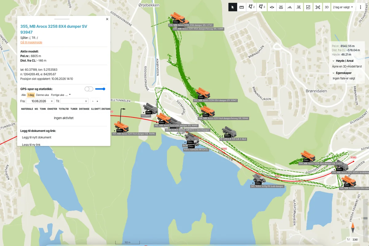
The value emerges when production data gains geographical context. You can see not just what has been done, but where it has been done and how it aligns with the projected model.
Project management can see which areas have been completed, where production is ahead of or behind schedule, and which parts of the project require attention. This provides a better basis for progress control and resource management throughout the project.
”Real-time data is about being able to react while the project can still be influenced. When you see both the production and its location in the same system, decisions become faster and better.”
— Steffen Nerdal, CCO at Ditio AS
Better documentation throughout the project
Documentation is critical throughout the entire project lifecycle, from quality assurance and HSE to final settlement and handover.
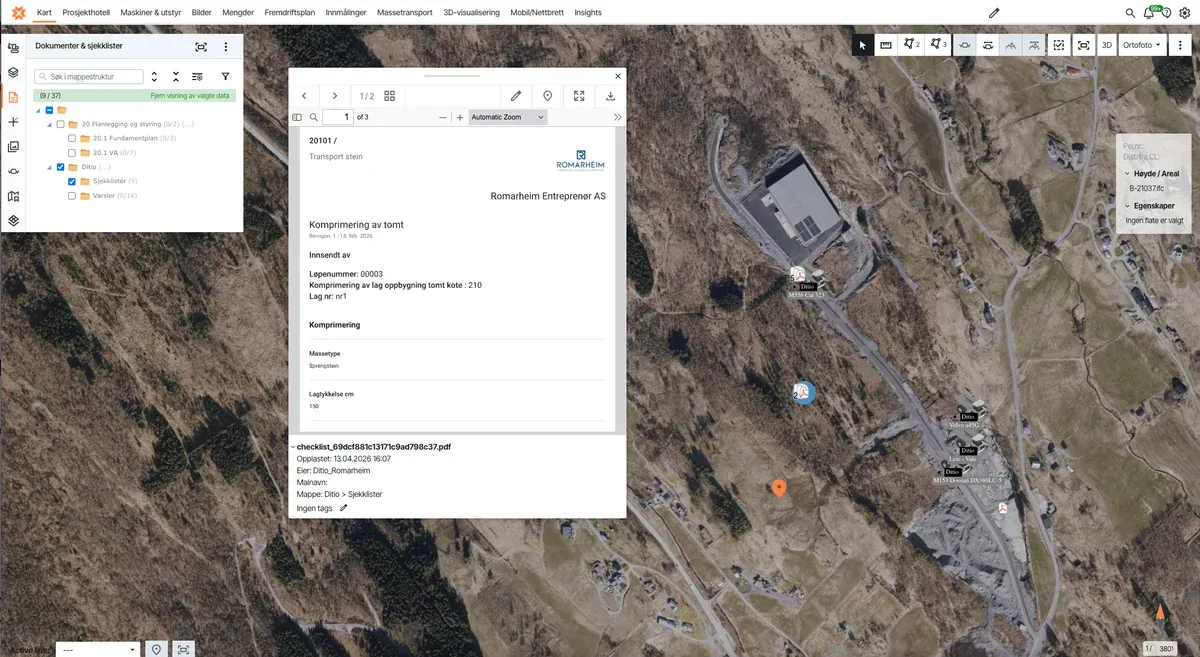
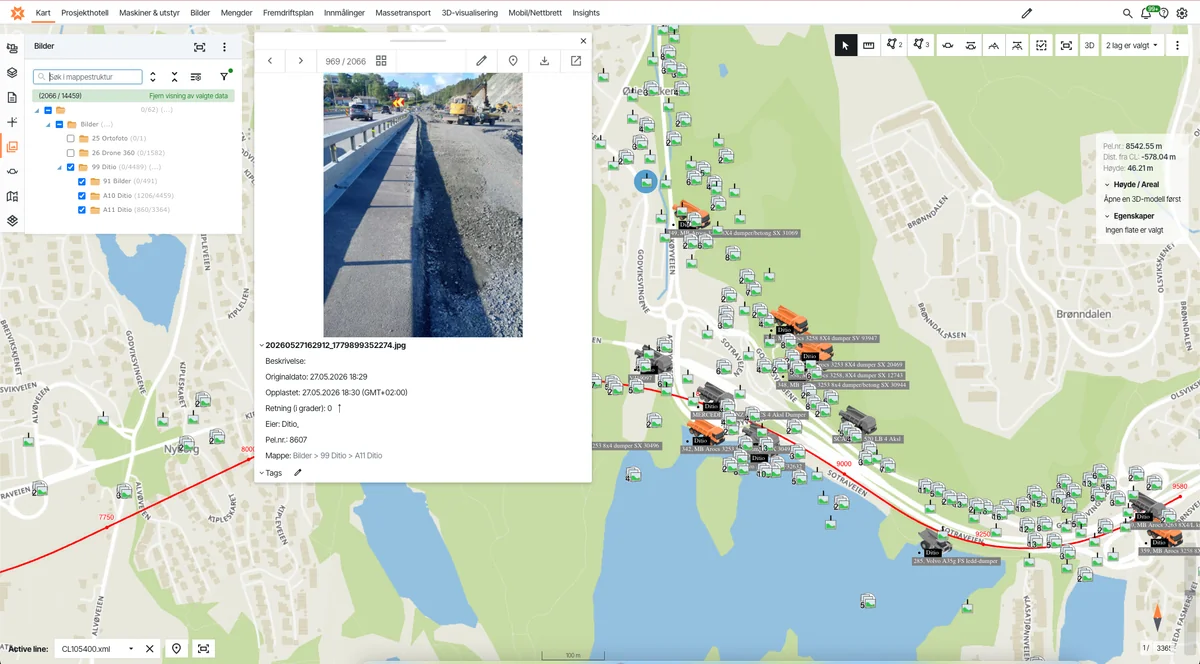
Ditio documents hours, images, deviations and mass transport with timestamps and position data. When this documentation is connected to Infrakit’s model and map foundation, it simultaneously gains a clear geographical context.
A deviation can be placed directly on the map. An image can be linked to the correct area in the model. Completed work can be traced back to both time, location and resource use.
This provides better traceability, less uncertainty and a stronger foundation for reporting and final settlement.
More profitable project delivery
Profitability is largely about making good decisions early enough.
When Ditio and Infrakit bring together field data and model information in one shared project context, the project team has access to the same up-to-date situational picture. This makes it easier to coordinate work, reduce rework and ensure that resources are used where they deliver the greatest value.
”The most profitable projects are often those that detect and act on deviations early.”
— Steffen Nerdal, CCO at Ditio AS
The result is better control of the project’s development, faster decisions and a stronger foundation for delivering projects on time and within budget.
Want to see how this works in practice?
Contractors use Ditio and Infrakit to bring field data, documentation and project information into one workflow. The result is better visibility, faster decisions and less rework.
One shared picture of the project
The integration between Ditio and Infrakit is more than a technical connection between two systems. It turns data into decision-making power.
How Ditio and Infrakit deliver better project control
- Field data and map model connected in real time
- Better progress control and resource management
- Geographical context on all documentation
- Faster decisions based on up-to-date information
- Better traceability for reporting and final settlement
- More profitable project delivery
The future of construction projects is not about collecting as much data as possible. It is about making data available to those who need to make decisions.
When field data, BIM models and map data are brought together in one shared project context via the integration between Ditio and Infrakit, contractors gain better control of progress, documentation and finances while work is still under way.
That is when construction data becomes decision-making power.
Frequently asked questions about Ditio and Infrakit
What is Infrakit, and what is it used for?
Infrakit is a Finnish map-based project platform for infrastructure that brings together BIM models, surveying data, machine control and drone data in one solution. The platform is used by contractors and infrastructure owners to visualise and manage projects in maps and 3D models, so that everyone involved always works from the same up-to-date situational picture.
How does the integration between Ditio and Infrakit work?
The integration is API-based and sends data from Ditio directly to Infrakit in real time. Field documentation such as images, checklist PDFs and deviation PDFs are automatically exported to your Infrakit folders as soon as they are created in Ditio. Machine positions and completed transport trips from Ditio Flow are continuously streamed to Infrakit, so that equipment position and transport documentation are always synchronised.
What is the difference between Ditio and Infrakit?
Ditio is a field-based platform for digital data capture — it records hours, crew, mass transport, deviations and production directly from the construction site. Infrakit is a map-based project platform that visualises BIM models, surveying data and machine control. The two solve different challenges but complement each other: Ditio tells you what is happening in the field, Infrakit shows where it is happening and how it aligns with the project model.
What types of projects is the integration suited for?
The integration is particularly valuable for larger infrastructure projects with many parties involved — such as road and rail construction, water and sewage works, and groundworks — where it is critical to maintain alignment between field production and the project model. It suits contractors who already use, or are considering adopting, BIM and model-based project management.
How do I get started with Ditio and Infrakit together?
The integration is activated through Ditio’s integration setup and requires active accounts in both systems. Contact Ditio for a demo and we will help you with setup and configuration for your project. See also our overview of all integrations.
Related articles